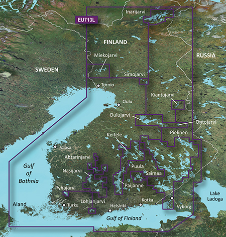
Garmin BlueChart g2 vision VEU713L - Finland V 11.50
Detailed coverage of the Finnish coast along the Gulf of Bothnia and into the Gulf of Finland. Coverage extends from Tornio, Fin. to Vyborg, Rus., including Oulu, Turku, Helsinki, and Kotka in Finland, as well as Hailuoto and Vallgrund. Coverage also includes detail of inland Finnish lakes including Inarijarvi, Miekojarvi, Simojarvi, Kiantajarvi, and Lohjanjarvi. Also includes detailed coverage of Oulujarvi, Pielinen, Saimaa, Paijanne, Nasijarvi, and others. General coverage of the Estonian and Russian coasts along the Gulf of Finland.
infos
Code:Please Login or Register to see the linkslocked imgCode:Please Login or Register to see the links
PID 1, FID 2027, region 4,19
unlock with
[Only registered and activated users can see links. ]
rename it gmapsupp.img and copy in a Garmin directory in sd
Originally it was a demo version map (DEU713L), demo flag has been removed with Gmaptool
VEU713L UnLocked - Part 1 ([Only registered and activated users can see links. ]) (430 MB)
VEU713L UnLocked - Part 2 ([Only registered and activated users can see links. ]) (430 MB)
VEU713L UnLocked - Part 3 ([Only registered and activated users can see links. ]) (430 MB)
VEU713L UnLocked - Part 4 ([Only registered and activated users can see links. ]) (375 MB)
or
[Only registered and activated users can see links. ]
[Only registered and activated users can see links. ]
[Only registered and activated users can see links. ]
[Only registered and activated users can see links. ]
[Only registered and activated users can see links. ]
[Only registered and activated users can see links. ]
[Only registered and activated users can see links. ]
[Only registered and activated users can see links. ]
new version in post n8
Welcome guest, is this your first visit? Click the "Create Account" button now to join.
Results 11 to 20 of 21
Threaded View
-
19th July 2011, 04:56 PM #1
 Garmin BlueChart g2 vision VEU713L - Finland up to V.14.00

You have to navigate to get to the good.
Galaxy S5 Kitkat 4.4.2 / Nuvi1200->1250 / Nuvi3790T->34xx / Nuvi 2200 / Nuvi 66 / Oregon 600


 Likes:


 Reply With Quote

Bookmarks