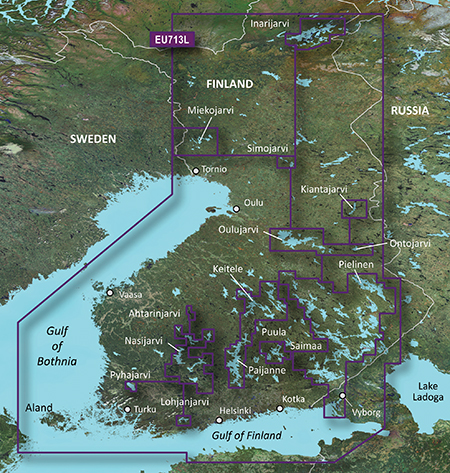
Garmin BlueChart g2 vision VEU713L - Finland V 11.50
Detailed coverage of the Finnish coast along the Gulf of Bothnia and into the Gulf of Finland. Coverage extends from Tornio, Fin. to Vyborg, Rus., including Oulu, Turku, Helsinki, and Kotka in Finland, as well as Hailuoto and Vallgrund. Coverage also includes detail of inland Finnish lakes including Inarijarvi, Miekojarvi, Simojarvi, Kiantajarvi, and Lohjanjarvi. Also includes detailed coverage of Oulujarvi, Pielinen, Saimaa, Paijanne, Nasijarvi, and others. General coverage of the Estonian and Russian coasts along the Gulf of Finland.
infos
Code:Please Login or Register to see the linkslocked imgCode:Please Login or Register to see the links
PID 1, FID 2027, region 4,19
unlock with
[Only registered and activated users can see links. ]
rename it gmapsupp.img and copy in a Garmin directory in sd
Originally it was a demo version map (DEU713L), demo flag has been removed with Gmaptool
VEU713L UnLocked - Part 1 ([Only registered and activated users can see links. ]) (430 MB)
VEU713L UnLocked - Part 2 ([Only registered and activated users can see links. ]) (430 MB)
VEU713L UnLocked - Part 3 ([Only registered and activated users can see links. ]) (430 MB)
VEU713L UnLocked - Part 4 ([Only registered and activated users can see links. ]) (375 MB)
or
[Only registered and activated users can see links. ]
[Only registered and activated users can see links. ]
[Only registered and activated users can see links. ]
[Only registered and activated users can see links. ]
[Only registered and activated users can see links. ]
[Only registered and activated users can see links. ]
[Only registered and activated users can see links. ]
[Only registered and activated users can see links. ]
new version in post n8
Welcome guest, is this your first visit? Click the "Create Account" button now to join.
Results 1 to 10 of 21
Hybrid View
-
19th July 2011, 04:56 PM #1
 Garmin BlueChart g2 vision VEU713L - Finland up to V.14.00

You have to navigate to get to the good.
Galaxy S5 Kitkat 4.4.2 / Nuvi1200->1250 / Nuvi3790T->34xx / Nuvi 2200 / Nuvi 66 / Oregon 600
-
19th July 2011, 11:05 PM #2pietuGuest

Old post............
Last edited by pietu; 12th August 2012 at 01:02 AM.
-
24th August 2011, 12:04 AM #3varjomiesGuest
-
12th January 2013, 03:18 PM #4Junior Member


- Join Date
- Jan 2013
- Location
- EU
- Posts
- 6
- Rep Power
- 0

Can someone guide how to make this into microSD card what do i need?
Fresh MicroSD card and adapter to pc?
thanksLast edited by derath; 12th January 2013 at 03:26 PM.
-
12th January 2013, 04:01 PM #5
-
12th January 2013, 05:50 PM #6Junior Member


- Join Date
- Jan 2013
- Location
- EU
- Posts
- 6
- Rep Power
- 0

Im going to buy this device: GARMIN GPSMAP 527xs (available after 20.1.2013)
Does it have a microSD card where i can upload this .IMG map by default?
Or do i need to make one somehow?
Totally newb with these...
ALSO can someone reupload this, the links are deleted/not working.. Thanks alot!
( the file i downloaded from - none of the other works [Only registered and activated users can see links. ] were corrupt)
We need new links!Last edited by derath; 12th January 2013 at 08:32 PM.
-
12th January 2013, 09:28 PM #7

It actually has 2 slots for microSD cards.
Code:Please Login or Register to see the links
Be patient. If pietu, catymag, or someone else can fix it, they will (hopefully before you get your new Sounder).ALSO ..........
We need new links! 'Thanking Posts' are banned. To thank someone, and/or to see hidden links and content, use the [Only registered and activated users can see links. ] button below left of the helpful post then refresh your browser [F5 key]. 'Thanking Posts' are banned.
Please don't spam. Posts serving no purpose other than to thank or to ask about hidden links are trashed or deleted, it's GPSPower's policy. Please don't spam.
[Only registered and activated users can see links. ] should make their first post as a new Intro Thread in [Only registered and activated users can see links. ].
-
12th January 2013, 11:12 PM #8

Last edited by catymag; 8th July 2013 at 11:36 AM. Reason: link replaced
-
13th January 2013, 12:32 AM #9Junior Member


- Join Date
- Jan 2013
- Location
- EU
- Posts
- 6
- Rep Power
- 0

Thanks alot, this is the best community i ever been with !
Ill notice how it works with the new GARMIN GPSMAP 527xs once i get it.
No more hitting rocks at sea i hope... safe sailing for all.
--All working fine so far unlocked .IMG ready for insert
Last edited by derath; 13th January 2013 at 01:19 AM.
-
8th February 2013, 05:30 PM #10Junior Member


- Join Date
- Jan 2013
- Location
- EU
- Posts
- 6
- Rep Power
- 0

So can this unlocked .IMG be added to MicroSDHC in Garmin folder and it will work ?= )
And how old is this map? friend has 3 years older map showing more detail from 1 lake here... ( more depth information )
Under view / chart views -Homeport program theres only navigation chart available this could be the problem, no fishing chart :<Last edited by derath; 8th February 2013 at 05:36 PM.


 Likes:


 Reply With Quote


Bookmarks