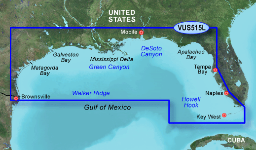
I have copied this file into the Garmin folder on an SD card and loaded it on my GPSMAP 546s. Although the unit indicates the Brownsville - Key Largo supplemental maps have loaded and "System Information" indicates the VUS515L maps are loaded, I can't see any difference from the maps that are preloaded on the unit. There is no Satellite imagery nor a menu option to activate such imagery. Also there are no aerial photos. Is there some other
process I need to perform on this file before loading it to the SD Card?
Thanks
Welcome guest, is this your first visit? Click the "Create Account" button now to join.
Results 1 to 10 of 25
-
23rd January 2010, 10:39 PM #1Member +


- Join Date
- Nov 2009
- Posts
- 31
- Rep Power
- 44
 Garmin BlueChart g2 Vision VUS515L-Brownsville - Key Largo (10.50)+(11.50)
Garmin BlueChart g2 Vision VUS515L-Brownsville - Key Largo (10.50)

Detailed coverage of the Gulf of Mexico from Brownsville, TX to Plantation Key, FL including Corpus Christi, TX, Matagorda Bay, Galveston Bay, Port Arthur, TX, Atchafalaya Bay, the Mississippi Delta, Chandeleur Islands, Tampa Bay and the Florida Keys west of Key Largo. Also includes Lake Ponchartrain and Lake Maurepas to Vermilion Bay and Lake Calcasieu. Bathymetric coverage of offshore features from Vernon Basin to Alaminos Canyon including DeSoto Canyon, Mississippi Canyon and Green Canyon.
more info
MapID=488Code:Please Login or Register to see the links
Unlocked IMG-file
[Only registered and activated users can see links. ]
[Only registered and activated users can see links. ]
thanks to our friend who supplied it
update in post 24
-
18th December 2010, 10:10 PM #2Member


- Join Date
- Dec 2010
- Location
- Texas
- Posts
- 14
- Rep Power
- 0

-
19th December 2010, 03:15 AM #3

Some of the unlocked charts ,unlocked with old unlockers versions, the added GPS plotter features of g2 Vision charts are sometimes not all working - It's always preferable to share locked maps-

You have to navigate to get to the good.
Galaxy S5 Kitkat 4.4.2 / Nuvi1200->1250 / Nuvi3790T->34xx / Nuvi 2200 / Nuvi 66 / Oregon 600
-
19th December 2010, 03:21 AM #4Member


- Join Date
- Dec 2010
- Location
- Texas
- Posts
- 14
- Rep Power
- 0

Thank You. I have this card on order. When it arrives, I will try to skull it out and share.
Great Forum
-
19th December 2010, 03:26 AM #5
-
22nd December 2010, 09:19 PM #6Member


- Join Date
- Dec 2010
- Location
- Texas
- Posts
- 14
- Rep Power
- 0

Here is VUS515L - Brownsville to Key Largo - Locked. I unlocked it with Fast Unlocker 1.5 and it worked in my unit. I hope this works.
lLast edited by catymag; 24th February 2012 at 01:42 AM. Reason: nice thanks rep+ -- deleted Megaupload invalid links
-
23rd December 2010, 03:05 AM #7

Thanks a lot
this is newer version V 11.50
PID 1, FID 2024, region 4,32
Code:Please Login or Register to see the links

You have to navigate to get to the good.
Galaxy S5 Kitkat 4.4.2 / Nuvi1200->1250 / Nuvi3790T->34xx / Nuvi 2200 / Nuvi 66 / Oregon 600
-
16th January 2011, 06:52 PM #8divepcolaGuest

flic
I copied these files: [Only registered and activated users can see links. ]
[Only registered and activated users can see links. ]
to my SD card and into the Garmin folder, however the 740s says it does not recognize the format. Can you give my step by step instructions on how to do it right? I'd greatly appreciate it. Divepcola
catymag
Thanks for posting the newer version. SO how do we get it onto the SD card and unlock it? Thanks for any help...... DivepcolaLast edited by catymag; 16th January 2011 at 09:01 PM. Reason: merged 2 consec. posts
-
16th January 2011, 09:00 PM #9


You have to navigate to get to the good.
Galaxy S5 Kitkat 4.4.2 / Nuvi1200->1250 / Nuvi3790T->34xx / Nuvi 2200 / Nuvi 66 / Oregon 600
-
16th January 2011, 10:02 PM #10divepcolaGuest

THANKS for responding. "These 2 links in post n1 point to 2 splitted rared files, extract them in one file, using winrar.
Rename the resulting file as gmapsupp.img, copy it in a Garmin folder on your sd-"
I actually spent the last few hours doing that. When I put it in the unit, on boot up is didn't load the normal maps. It said Map G2 3.5, however, nothing was available and on checking system Info, it said the map format was not recognized. Man this has been frustrating.
I also copied the newer 11.5 verison you posted, put it into note pad and saved it as all files and into gmapsupp.img, but can't seem to download the Fast Unlocker anywhere. I feel like a total dumb azz here. LOL
Can you give me step by step intsructions and if I need fast unlocker, where can I get it? The Megaupload site didn't work.
Again, I DO appreciate it.


 Likes:


Bookmarks