Sorry, but I didn't find that info: does it plot the position of the connected GPS into the map?
Welcome guest, is this your first visit? Click the "Create Account" button now to join.
Results 1 to 10 of 11
-
15th October 2013, 08:41 PM #1
 TopoNavigator 6 - Anavasi Digital - Up to 6.41
TopoNavigator 6 is the sole Greek cartographic software program and is addressing all those involved with the geographical area - hikers, researchers, off-roaders, technical and scientific companies or organizations. The software has been built entirely by Greek engineers and integrates complete road, geographical and topographical data for Greece within a GIS environment.
The strong points that differentiate TopoNavigator 6 from any other mapping software are:
- Complete geographic data for Greece and neighboring regions (not scanned maps or design sketches, but high precision vector data) managed by a powerfull automatic map composition engine.
- Exchanges data with all Garmin and Magellan GPS.
- Creates and loads routable maps for all Garmin GPS.
- Creates and loads cartographic images on newer Garmin GPS (CustomMaps).
- Modern tools of editing, import, and export of data and maps.
Bilingual application:
Menus, messages, user manual: either in greek or in english.
Map labels (cities, place names, etc.): either in greek or in english or both.
ENVIRONMENT
1. New GUI with 14 function groups. Groups collapse to free-up screen space.
2. GGRS87 workspace with direct creation of Garmin GPS compatible maps.
3. New interactive Overmap group.
4. Improved 20 m interval contour lines data set.
5. More cartographic data on any thematic layer (ex.g. > 10.000 place names added), yet 3 GB lesser disk space and 110 Mb lesser RAM used. Faster programm loading and response.
6. Six user profiles adjust information prioratization, density and symbology to create more readable thematic maps.
7. New tool to customize on-map display of information and editing tool sets.
Spoiler: Screenshots
TERRAIN ANALYSIS
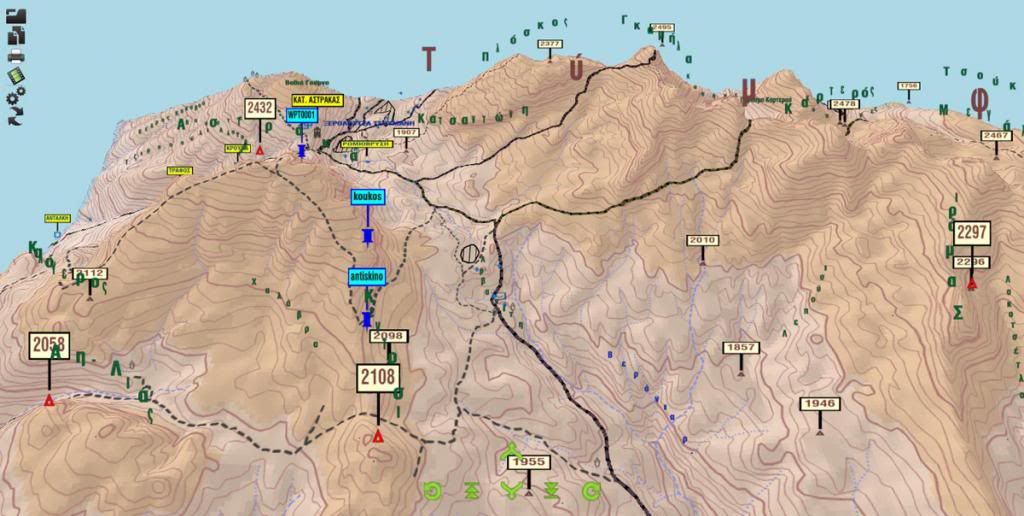
8. New terrain representation engine based on detailed 30m cell-size Digital Elevation Model; offers real-time shaded relief generation with adjustable elevation-zones color palette, relief-slope combination and aspect analysis.
9. Slope and elevation for any map point are displayed on MouseMove in status bar.
10. Viewshed algorithm (visiual impact analysis) using numerous real-world parameters.
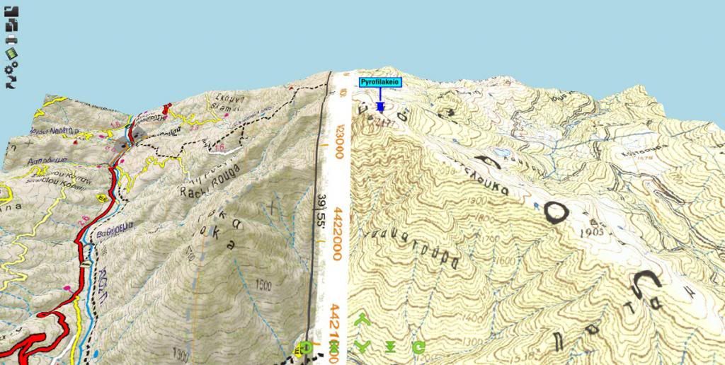
11. New 3D viewer offers real 3D symbology and labeling.
Spoiler: Screenshots
ROUTING
12. Improved routing engine. Roadbook is adapted to user profile.
13. New multicriteria routing algorithm creates and evaluates hiking routes in any region.
Spoiler: Screenshots
TOOLS
14. New Favorites data group supports points, polylines, Highlighted lines, Slope profile analysis, polygons and Geo-comments. Favorites are sticky (stored and recalled automatical on next start-up) and can be send to your GPS.
15. New "Navigate" digitize tool tranfers directly network geometry to a new track.
16. New "Network" digitize method: node creation (split-n-snap) on any intersection of new line on existing ones.
17. On line digitalization, auto-snap of new vertex to map features.
18. On point digitalization, auto-snap of new waypoint to trigo points.
19. New tools Align & Distribute to correlate positions of points, lines, polygons and vertices.
DATA EDITING
21. New data format TML with XML structure.
22. New XML format for Configuration settings (.ini) and map composition (.tvm) files.
23. New track and routings elevation profile engine.
24. New File Properties group of tools offers Unique Values and Class Breaks symbology and labeling, selection of records by attibutes, elevation profile and values statistic analysis.
25. Improved vector files (shapefiles, coverages & CAD files) handling engine now supports large files management.
26. New smart tools (feature properties transfer, geometry cloning etc) highily facilitate data editing.
27. Numerous new spatial analysis tools like Voronoi and Triangulation diagrams for any type of data and map feature, Convex hull of any type of data, minimum spaning tree etc.
28. New topological analysis toolbox offers easy polyline intersection, smart multi-lines union, append shape to ppolygon, split polygon, clip line to polygon, network errors analysis etc.
29. New automated extraction of geometry from random text file format.
30. Direct ΝΜΕΑ file import.
31. New KML variations adopted
32. Simplified image georeferencing technique.
33. Direct use of WMS (satelite images and ortho-maps) and projection to GGRS87.
34. New Roadsign symbol palette.
20. New Generate tool creates and distributes points, lines & polygons.
Spoiler: Screenshots
After updating software with Upgrade_TopoNavigator6xx.exe user must do an update for Road and Topo map, these are two different procedures, within the app TopoNavigator 6. Untill version 6.1.0 user could choose the color pallete he wanted to use for updating the map. Two choices available one emphasizing road network map & the other emphasizing topo map. I couldn't find this feature in latest 6.1.1 update. After updating both road and topo map user can send the map as a Garmin IMG file to his/her registered device
Spoiler: Screenshots
Here is a look of the map in GMapTool
Spoiler: Screenshots
TopoNavigator 6 PC
Current Version 6.4.1
Improvements
Versions HOME & GIS. NEW: Numerous improvements and bug fixes.
MAP DATA
Additions in the Peloponnese, Central Greece, Epirus and Thessaly
HOW TO UPGRADE
Copy the file Upgrade_TopoNavigator6xx.exe to any location on your computer.
Double click on it and decompress the files in a temporary folder. Then the files are automatically transferred to the appropriate folders. A message tells you when the process is complete.
After the upgrade, you have to update the topographic and road map for Garmin GPS,a process that takes 1h-1h30 'and 0h30' respectively, and send it to your GPS..
Info
Code:Please Login or Register to see the links
DownloadCode:Please Login or Register to see the links
Code:Please Login or Register to see the links
-
9th November 2013, 01:10 PM #2

-
9th November 2013, 02:54 PM #3

Our Garmin device that has been connected to PC to receive the map from TopoNavigator is an external storage device that the app reads it's xml to confirm that it's the one registered with it. To get valid GPS signal you must buy and use an external GPS unit connected with TopoNavigator.
[Only registered and activated users can see links. ]
-
9th November 2013, 04:28 PM #4

Here is the official page of TopoNavigator with info about external GPS unit:
Code:Please Login or Register to see the links
They selling a specific USB unit for 60� but the important thing is that you can see the specs and try to find something even better or something cheaper depending what you 're looking for. No support for Win 8 ...Code:Please Login or Register to see the links
-
10th November 2013, 01:00 PM #5

You can also use as an external antenna, any Garmin On The Trail device that has NMEA OUT capability (using a USB cable).
I use the 60c or 60csx as an antenna (Setup>Interface>Serial Data Format>NMEA In/NMEA Out).
In TopoNavigator6 Preferences, I choose Com Port>Garmin USB and Baud rate>4800
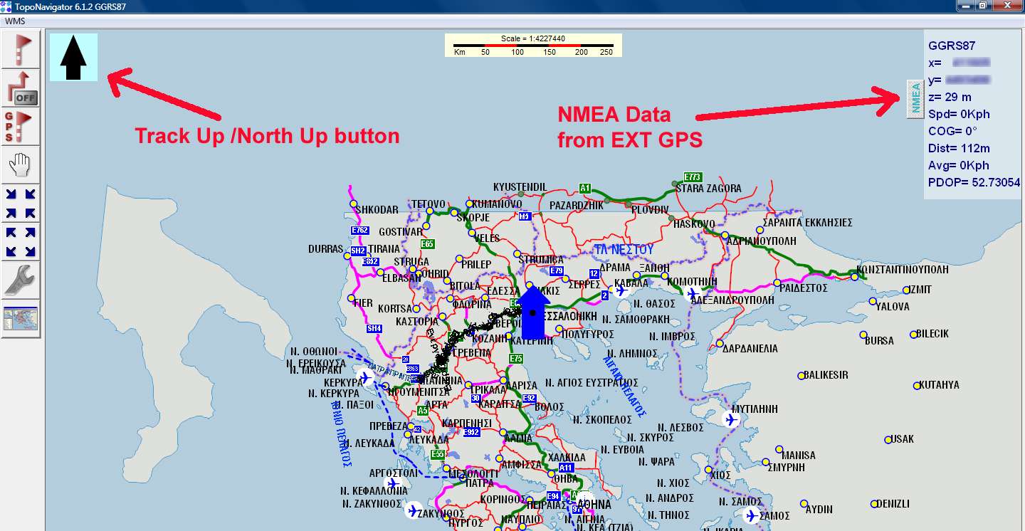
Then I press the GPS connect button from the NMEA menu and the program goes into Tracking/Navigating Mode.
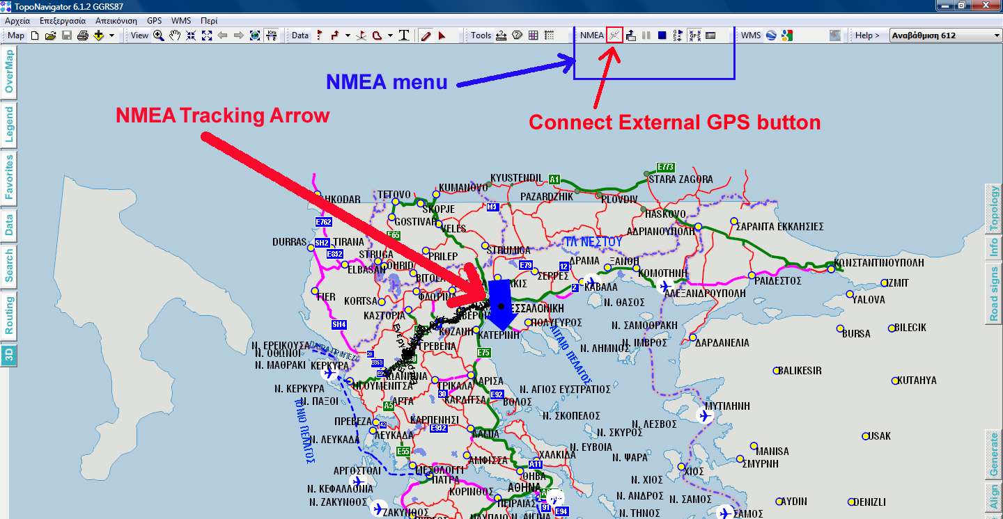
There is also a dedicated page view (F5) for Tracking/Navigating.

-
30th November 2013, 03:14 PM #6

Hi
I downloaded the update,now what? where is the main program? I get 'Path not found'
-
30th November 2013, 05:48 PM #7
-
30th November 2013, 09:11 PM #8

Cant find topoNavigator 6.01 here..where do i get it from?
-
25th February 2015, 01:40 PM #9Junior Member


- Join Date
- Feb 2015
- Location
- Irakleion
- Posts
- 1
- Rep Power
- 0

hi guys, I m trying to find the first setup.exe 6.01 to install the program??????
where do i get it from? First post updated with TopoNavigator 6.34. ??????Where
-
25th February 2015, 06:39 PM #10

Even if you had the initial set up exe file you won't be able to use it because TopoNavigator requires serial keys to get the app started. These keys depend on your HDD hosting the OS and as i found out myself recently if for some reason you change motherboard those keys don't work anymore.
You can find the link for downloading the 6.34 update inside Code tag.


 Likes:



 Reply With Quote

Bookmarks