park4night has - our own experience - the worst sorting of all providers. In addition, there are a lot of parking lots / rest areas that you can only drive to with a van, which is often only tolerated, not officially.
I was a user of park4night from the very beginning, when there was still sorted KML. At the beginning with the app it was no longer fun.
** The collection is also very specifically French, e.g. many camper POIs are missing in DE. IMO campercontact and / or promobil and acsi are much more helpful here across the EU
I think today it is better to use one of the many apps with an online connection, because of the information, and then the selected location to share the GPS position with the navigation app.
just my very personal opinion.....
Welcome guest, is this your first visit? Click the "Create Account" button now to join.
Results 11 to 20 of 27
-
10th May 2021, 04:53 PM #11Member +


- Join Date
- Mar 2013
- Location
- germany
- Age
- 75
- Posts
- 75
- Rep Power
- 39

The data in park4night is extremely inconsistent. Sorting would be very time-consuming and not always possible.
There is no real order to the data in the app. Everyone writes as they like, and in the style of their own language.
So you would first have to learn several languages.
This is more possible with the professional providers.
-
11th May 2021, 08:21 AM #12Master


- Join Date
- Mar 2017
- Location
- Germany
- Posts
- 969
- Rep Power
- 755

Last edited by rondoan; 11th May 2021 at 08:26 AM.
---
ex calipoint say: my Knowledge of today is what I read yesterday 🧐😉
-
11th May 2021, 12:11 PM #13Member +


- Join Date
- Mar 2013
- Location
- germany
- Age
- 75
- Posts
- 75
- Rep Power
- 39

I use MapsMe with specially adapted kml files for planning. The pins are then coloured differently depending on the type of place. I can then see immediately what kind of places are available at my destination.
The whole thing is then accompanied by a proper description.
Since I use the same kml files on my navigation system, the transfer is no problem.
I don't like to rely on online data, just old school.
Spoiler: Screenshot
-
11th May 2021, 03:24 PM #14Master


- Join Date
- Mar 2017
- Location
- Germany
- Posts
- 969
- Rep Power
- 755

😮 Aha! So you learned from user @calipoint, right 🤔

I think that for campers who have a Windows notebook / tablet with them, the Automapa program with always up-to-date HERE map is the best for planning with informative POIs! You can also call up URL information from the POI description at Automapa.
** In Automapa, the limited visibility of POIs on the map (zooming) can be programmed to e.g. 500Km by changing the INI.
*** but in the end this is about the POI of park4nigth.....................Last edited by rondoan; 11th May 2021 at 03:43 PM.
---
ex calipoint say: my Knowledge of today is what I read yesterday 🧐😉
-
11th May 2021, 06:59 PM #15Member +


- Join Date
- Mar 2013
- Location
- germany
- Age
- 75
- Posts
- 75
- Rep Power
- 39

Hallo
Not quite.
calipoint hardly ever makes his own new POIs and he uses Excel.
I use SQLite databases to create my POIs.
But he sometimes adapts mine for other uses.
-
12th May 2021, 12:38 PM #16Master


- Join Date
- Mar 2017
- Location
- Germany
- Posts
- 969
- Rep Power
- 755

my friend, you are so wrong!

@calipoint mostly "modifies" your 'stolen' POI or converts ASC files (re-organized) into usable KML with the help of 'OpenOffice'.
@calipiont has its own camper POI (ccg), and currently e-bike charging stations DE, researched it and wrote Placemark for Placemark with a text editor!Last edited by rondoan; 14th May 2021 at 08:19 AM.
---
ex calipoint say: my Knowledge of today is what I read yesterday 🧐😉
-
12th May 2021, 05:24 PM #17Member +


- Join Date
- Mar 2013
- Location
- germany
- Age
- 75
- Posts
- 75
- Rep Power
- 39

I have created a private copy of Park4night Europa without 4x4 here for test purposes. (only for WinCE)
It is separated by country. So you can simply delete countries you don't need.
Place type designations are the original French abbreviations.
Descriptions, if available, are in English, otherwise original.
If available, also telephone numbers and websites
[Only registered and activated users can see links. ]
-
30th December 2021, 11:45 PM #18

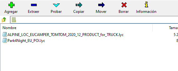
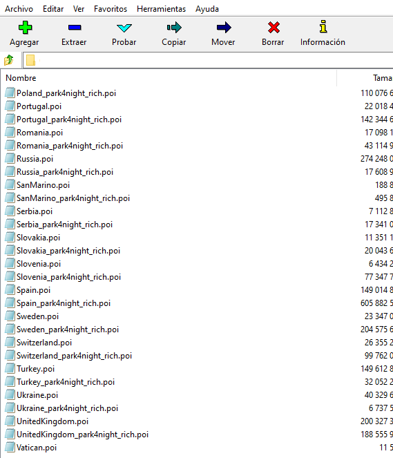
It looks like this year NNG uses Park4night as their official POI for motorhome, camper car and van:
Spoiler: pic
Anyone who wants to see it can consult since the last update from alpine.co.uk:
Spoiler: link
I repeat, it can only be seen, they are encrypted and password protected. •●» If you find any dead links on my posts please PM me & I'll try to fix/reload «●•
-
31st December 2021, 02:54 PM #19Master


- Join Date
- Mar 2017
- Location
- Germany
- Posts
- 969
- Rep Power
- 755

?? and why is something so "worthless" published ;(
! * The POI is available from a user @ HansGans09 as usable KML, just write to him once
*** Wish a happy new year! ***---
ex calipoint say: my Knowledge of today is what I read yesterday 🧐😉
-
31st December 2021, 04:51 PM #20

The intent and purpose of my post is informational, I think this is the best place on the forum to inform you about the new Park4Night update on iGO.
For your information, the Park4night KML posted by @HansGans09 are not the Park4Night originals, but the official ones. The original Park4night KML are divided by categories and not by countries, the latest update of the Park4night KML archives, is dated November 21, 2021, has all the information from the park4night webpage.
If moderators think this is useless, move it to trash.
Happy New Year •●» If you find any dead links on my posts please PM me & I'll try to fix/reload «●•


 Likes:
 Reply With Quote


Bookmarks