BlueChart®
BlueChart® g2
Compatible products for this item are:
microSD™/SD™ card-compatible products
Colorado® 300
Colorado® 400c
Colorado® 400i
Colorado® 400t
Dakota® 20
GPSMAP® 6012
GPSMAP® 6212
GPSMAP® 7212
GPSMAP® 4008
GPSMAP® 4010
GPSMAP® 4012
GPSMAP® 420/420s
GPSMAP® 4208
GPSMAP® 421/421s
GPSMAP® 4210
GPSMAP® 4212
GPSMAP® 430/430s
GPSMAP® 431/431s
GPSMAP® 440/440s
GPSMAP® 441/441s
GPSMAP® 5008
GPSMAP® 5012
GPSMAP® 5015
GPSMAP® 520/520s
GPSMAP® 5208
GPSMAP® 521/521s
GPSMAP® 5212
GPSMAP® 5215
GPSMAP® 525/525s
GPSMAP® 526/526s
GPSMAP® 530/530s
GPSMAP® 531/531s
GPSMAP® 535/535s
GPSMAP® 536/536s
GPSMAP® 540/540s
GPSMAP® 541/541s
GPSMAP® 545/545s
GPSMAP® 546/546s
GPSMAP® 6008
GPSMAP® 60CSx
GPSMAP® 60Cx
GPSMAP® 620
GPSMAP® 6208
GPSMAP® 62s
GPSMAP® 62st
GPSMAP® 640
GPSMAP® 7012
GPSMAP® 7015
GPSMAP® 720/720s
GPSMAP® 7215
GPSMAP® 740/740s
GPSMAP® 76CSx
GPSMAP® 76Cx
GPSMAP® 78
GPSMAP® 78s
GPSMAP® 78sc
nüvi® 500
nüvi® 550
Oregon® 200
Oregon® 300
Oregon® 400c
Oregon® 400i
Oregon® 400t
Oregon® 450
Oregon® 450t
Oregon® 550
Oregon® 550t
Rino® 520HCx
Rino® 530HCx
Garmin card-compatible products
GPSMAP® 192C
GPSMAP® 198C Sounder
GPSMAP® 2106
GPSMAP® 2110
GPSMAP® 2206
GPSMAP® 2210
GPSMAP® 276C
GPSMAP® 278
GPSMAP® 292
GPSMAP® 298 Sounder
GPSMAP® 3006C
GPSMAP® 3010C
GPSMAP® 3205
GPSMAP® 3206
GPSMAP® 3210
GPSMAP® 376C
GPSMAP® 378
GPSMAP® 392
GPSMAP® 396
GPSMAP® 398 Sounder
GPSMAP® 478
GPSMAP® 492
GPSMAP® 498 Sounder
BlueChart® g2 Vision
microSD™/SD™ card-compatible products
GPSMAP® 6012
GPSMAP® 6212
GPSMAP® 7212
GPSMAP® 4008
GPSMAP® 4010
GPSMAP® 4012
GPSMAP® 420/420s
GPSMAP® 4208
GPSMAP® 421/421s
GPSMAP® 4210
GPSMAP® 4212
GPSMAP® 430/430s
GPSMAP® 431/431s
GPSMAP® 440/440s
GPSMAP® 441/441s
GPSMAP® 5008
GPSMAP® 5012
GPSMAP® 5015
GPSMAP® 5208
GPSMAP® 521/521s
GPSMAP® 5212
GPSMAP® 5215
GPSMAP® 525/525s
GPSMAP® 526/526s
GPSMAP® 530/530s
GPSMAP® 531/531s
GPSMAP® 535/535s
GPSMAP® 536/536s
GPSMAP® 540/540s
GPSMAP® 541/541s
GPSMAP® 545/545s
GPSMAP® 546/546s
GPSMAP® 6008
GPSMAP® 620
GPSMAP® 6208
GPSMAP® 640
GPSMAP® 7012
GPSMAP® 7015
GPSMAP® 720/720s
GPSMAP® 7215
GPSMAP® 740/740s
note:Not all features of BlueChart® g2 and BlueChart® g2 Vision maps will work with all devices
There are certain elements of these mapping products that were designed for use on dedicated Marine GPS products that will not be displayed on a nuvi, zumo ,Colorado 62s,Dakota or StreetPilot or other outdoor device. If you would like to use these mapping products and experience the highest level of detail and functionality, it is recommended that they be used on a dedicated Marine GPS product.
In addition, when viewing this mapping on your device, please ensure that you have disabled your City Navigator mapping and changed your Map View from the default 3D view to either Track Up or North Up:
From the main menu touch Tools
Touch Settings (Not required for all devices)
Touch Map
Touch Info/Map Info
Uncheck City Navigator to disable the street mapping (please remember to check this box after use to restore street mapping)
Touch Back
Change your Map View either North Up or Track Up
Press and hold Back to return to the main menu
Your nuvi, zumo or StreetPilot is now ready for use with Marine mapping. Please remember that many automotive devices are not waterproof and should be treated carefully when being used near water.
The nuvi 500 and 550 will not experience many of these limitations
more infos
You cant see Bluechart G2 and BlueChart® g2 Vision in Mapsource, you need Homeport to see them on pc-Code:Please Login or Register to see the links
copy any Bluechart G2 img in an sd and insert it in your pc, Bluecharts G2are made for SDs, one per sd, you cant merge them, your Homeport will see just one map per sd-
more infos
Code:Please Login or Register to see the links

Welcome guest, is this your first visit? Click the "Create Account" button now to join.
Results 1 to 6 of 6
-
31st August 2010, 08:24 PM #1questor1971Guest
 BlueChart compatibility for different Garmin devices
G2 Vision has a lot of extra features i.e. Fish Eye, Mariner’s Eye view, and tides etc....
Has anyone done a list of compatible units? (Which include firmware levels)
I'm running BlueChart on my "car" gps so I know some wild combos are possible.
First post for me by the wayLast edited by catymag; 3rd September 2010 at 12:11 AM. Reason: moved to proper section
-
23rd September 2010, 11:19 AM #2

Last edited by catymag; 23rd September 2010 at 10:14 PM.

You have to navigate to get to the good.
Galaxy S5 Kitkat 4.4.2 / Nuvi1200->1250 / Nuvi3790T->34xx / Nuvi 2200 / Nuvi 66 / Oregon 600
-
23rd September 2010, 05:41 PM #3BallebarGuest
 BlueChart usage with Garmin HomePort & GMPC
About Garmin HomePort
It's possible to view as many marine IMG files as you have room for on your memory card or USB stick.
HomePort detects maps from the path "[X]:\Garmin\*.img". The file name(s) might be something like "VPC410S.img" instead of the common "gmapsupp.img".
If there's also a "[X]:\Garmin\GarminDevice.xml" file there could be IMG files in paths like "[X]:\.System\*.img" and "[X]:\Map\*.img" depending on the GarminDevice.xml structure.
HomePort example with VPC410S v10.50

Marine units and BlueChart compatible units shows marine charts with correct marine colors. The other units like nüvi for car usage & StreetPilot plus software products GMXT and GMPC shows water areas in quite dark blue. There's also lack of details for spot soundings and other marine chart details (tide water etc.).
The newer BlueChart g2 Vision v11.50 from 2010 are hard to use with GMXT & GMPC. Guessing that it would be problems with road navigators also.
GMPC distorted example with VPC410S v10.50

It might be sligtly better results with BlueChart g2 Vision in some of the Garmin car navigators. The color palette will most likely be wrong anyway and it's not easy to correct with TYP-files.
Some units (GPSMAP 620/640 & nüvi 5xx) can switch between car mode and marine mode and show a correct marine chart in the marine mode.
-
16th September 2011, 02:02 PM #4

Question: Is my Garmin Marine Device capable of displaying Safety Shading and/or Fishing Charts?
Answer:
Garmin Marine Software BlueChart g2 and g2 Vision offer many features that enhance a boater's experience when used in conjunction with a compatible Garmin Marine Device. While these features are intended to improve a users experience, only certain features of the mapping are compatible with specified devices. In this case, the Safety Shading and Fishing Charts features have specific criteria that needs to be met before they can be considered compatible with a Garmin Marine Device.
Safety Shading is a feature offered in both BlueChart g2 and g2 Vision products. This feature allows a user to enable contour shading for all depth contours shallower than user-defined safe depth.
Fishing Charts is a feature offered in both BlueChart g2 and g2 Vision products as well. Fishing Charts aid in viewing the bottom contours and depth soundings with less visual clutter on the display.
To determine whether your device can display one or both of these features, please consider the following:
If your device uses a microSD* card for expandable memory and mapping, your device is compatible with both Safety Shading and Fishing Charts.
If your device uses a proprietary Garmin Data Card for expandable memory or mapping and is BlueChart g2 compatible, your device is compatible with Safety Shading but NOT Fishing Charts.
*The Garmin GPSMAP 62s, GPSMAP 78, and Montana series of devices are compatible with both safety shading and fishing charts. The Colorado, Dakota, and Oregon series of devices are compatible with Fishing Charts, but not Safety Shading. All other Garmin handheld devices are not compatible with either Safety Shading or Fishing Charts.
If you would like to know if your proprietary Garmin Data Card device is compatible with BlueChart g2, please visit the following link
and view the Compatible Devices tab.Code:Please Login or Register to see the links
source GARMIN KNOWLEDGE BASECode:Please Login or Register to see the links
Code:Please Login or Register to see the links

You have to navigate to get to the good.
Galaxy S5 Kitkat 4.4.2 / Nuvi1200->1250 / Nuvi3790T->34xx / Nuvi 2200 / Nuvi 66 / Oregon 600
-
1st January 2013, 10:13 PM #5

All sea maps, either traditional Bluechart, G2 or G2 Vision, work without TYP files, as these do not display particularly detailed or multi-coloured images on shore. The Bluechart version does not offer green meadows, brown fields or even tree symbols in a forest. However, outdoor devices were designed to be used in a car or on a boat as well. For this reason, a partial support for NT and Bluechart (G2) was implemented.
So far, Garmin marine devices do not support TYP files (for freely definable symbols, colours and textures). In order to display polygons, only a few clearly defined colours and textures are available. Without TYP files, however, the priority of polygons cannot be defined. Maps that are displayed perfectly on Garmin outdoor or travel devices generally do have the same quality on marine devices and are therefore unusable.
fromCode:Please Login or Register to see the links

You have to navigate to get to the good.
Galaxy S5 Kitkat 4.4.2 / Nuvi1200->1250 / Nuvi3790T->34xx / Nuvi 2200 / Nuvi 66 / Oregon 600
-
17th January 2013, 03:09 PM #6

Mapping precision Bluechart ® g2 Vision
The sophisticated BlueChart g2 Vision, thanks to the faithful reproduction of the coast and points of reference, is the ideal solution for the most demanding customers who want to know and see 360 ° the characteristics of the sea and the surrounding environment while navigating.
Thanks the use of advanced features and functionality such as high-resolution satellite images, three-dimensional perspective views and dynamic display above and below the waterline, Auto Guidance technology for the automatic calculation of the route chosen, aerial photos of ports, marinas, and other points of interest, it is finally possible to obtain navigation data extremely realistic.
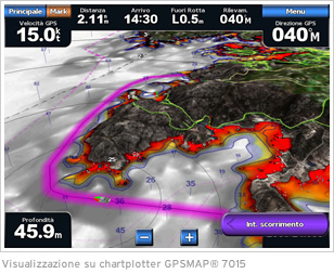
Mariner's Eye 3D
The functionality Mariner's Eye 3D provides a dynamic view in three-dimensional perspective of the land and compliance profiles of the fund.
-------------------------------------
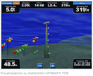
Fish Eye 3D
This innovative feature displays the conformity of the seafloor in 3D perspective below the water line and provide accurate depth data.
-------------------------------------
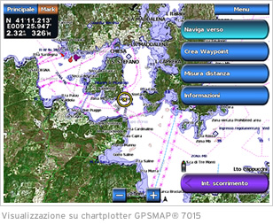
Auto Guidance
The Auto Guidance allows the automatic route calculation surest route to the destination chosen, through the reading of detailed map data in the Bluechart ® g2 Vision cartography.
-------------------------------------
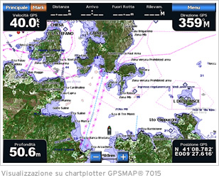
Satellite Imagery
Due to the overlapping of images on the high-resolution satellite maps, you can finally see precisely the morphology of the coast and get a realistic view of the surroundings.
-------------------------------------
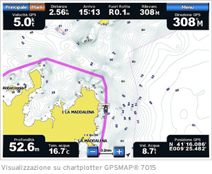
Fishing Maps
This function is extremely useful for fishermen provides detailed bathymetric data of the seabed to identify more precisely the most important fishing areas.
--------------------------------------
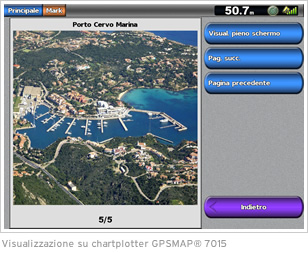
Photos of ports
The cartography Bluechart ® g2 Vision has a large database containing detailed photographs and high-resolution ports, marinas and other conspicuous points.
You have to navigate to get to the good.
Galaxy S5 Kitkat 4.4.2 / Nuvi1200->1250 / Nuvi3790T->34xx / Nuvi 2200 / Nuvi 66 / Oregon 600


 Likes:
 Reply With Quote




Bookmarks