Ι've been doing something like that since 2012 but differently.
I split a Bluechart for Mapsource, install it and then I choose all maps with Map tool.
I open the Bluechart with Gmaptool and go to Options > Info
I compare the the sub-maps in Mapsource map list with Gmaptool Info list and delete from Mapsource map list all the sub maps that do not have the "T" (Transparent) in Gmapstool Info list.
From Mapsource I sent to device all the remaining maps.
This is a Transparent map with only the contours in it.
Then I copy the original Bluechart on the device.
Now on device (3490) I have the Bluechart map (solid) with sea colors and no contours (because contours are part of Fishing Mode in a Bluechart).
I also have the Transparent contour map that I've sent with Mapsource.
If I check them together, I have a full Bluechart.
If I check the Transparent contour map with a Road map I can see the contour lines and the road map.
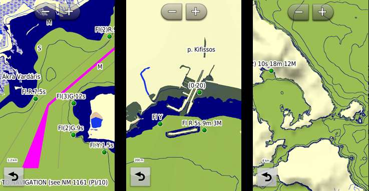
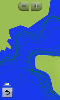
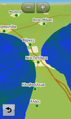
Bluechart original on 3490, checked alone
Bluechart original on 3490, checked with Mapsource's transparent contours
Mapsource's transparent contours, checked alone
Mapsource's transparent contours, checked with City Navigator Europe NTU
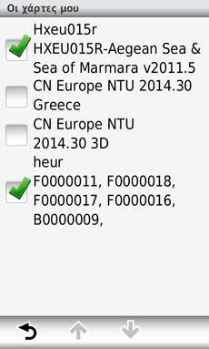
3490 map list
To post an image write the following that I have in the code:
Code:Please Login or Register to see the links
Welcome guest, is this your first visit? Click the "Create Account" button now to join.
Results 1 to 10 of 13
Thread: BlueChart on Nuvi 3590
-
28th November 2013, 07:57 AM #1
 BlueChart on Nuvi 3590
1. Please read: [Only registered and activated users can see links. ]
2. Please read: [Only registered and activated users can see links. ] "Write" Tab
3. Open gMapTool
4. Select Experimental Options
[Only registered and activated users can see links. ]
5. Add the BlueChart.img
6. In gMapTool Split the BlueChart.img into SubFiles
[Only registered and activated users can see links. ]
7. Move Transparent SubFiles (*.LBL *.RGN *.TRE) to Contours folder (Files marked T) (That's 3 SubFiles per *.MPC file below)
[Only registered and activated users can see links. ]
8. In gMapTool Add SubFiles (*.LBL *.RGN *.TRE) (ALL Files NOT marked T) (That's 3 SubFiles per *.MPC file above)
9. In gMapTool Write
Mapset (a name of your choosing)
set Transparency
Set draw priority
TRE parameters for SubFiles
[Only registered and activated users can see links. ]
10. In gMapTool Join the Subfiles (*.LBL *.RGN *.TRE) & (BLUCHART.MPS MARINAS.MDR MARINAS.SRT)
[Only registered and activated users can see links. ]
You now have a BlueChart map that (when selected) will be drawn over all other maps. (Deselect for On Road maps)
The SubFiles in the Contours folder also need to be joined (I also included BLUCHART.MPS, MARINAS.MDR & MARINAS.SRT)
The BlueChart Contours map can be left selected all the time (these are transparent lines) (in Step 9. Select Transparent)Last edited by l.l.l; 28th November 2013 at 11:40 PM. Reason: Screen shots in post #4
-
28th November 2013, 10:01 AM #2


-
28th November 2013, 10:22 AM #3

@ l.l.l
It's limit of 5 files in attachedLast edited by l.l.l; Today at 09:17 AM. Reason: Can't load screen shots !!!!!!!!!!! WHY ??????????? Perhaps NOEMAN's cache buffer is full Use the site of hosting image (imgur,tinypic,imageshack,etc....) and capture/insert the your URL in TAG [IMG] or click on incon Insert Image of icons-toolbar
-
28th November 2013, 11:50 AM #4

Screenshots from my Nuvi 3590
with Hxpc024r BlueChart AusNZ 2012 deSelected
[Only registered and activated users can see links. ][Only registered and activated users can see links. ]
with Hxpc024r BlueChart AusNZ 2012 Selected
[Only registered and activated users can see links. ][Only registered and activated users can see links. ]
with Hxpc024r BlueChart AusNZ 2012 & Australia & New Zealand DEM Selected
[Only registered and activated users can see links. ]
(o)(o)
=(_)=Last edited by l.l.l; 28th November 2013 at 11:20 PM. Reason: New Screenshots
-
28th November 2013, 01:12 PM #5

That's great I.I.I, now we have two methods two methods to visualize a Bluechart on Nuvi 3xxx plus to create a transparent depth contour map !!!

-
28th November 2013, 01:38 PM #6
-
28th November 2013, 11:08 PM #7Navigation software expert


- Join Date
- Apr 2009
- Location
- Suomi-Russia
- Age
- 58
- Posts
- 2,149
- Rep Power
- 729

It is pity but the main lack is absent depth spot???
Garmin, how much is 30 pieces of silver for Judas today? Were they worthy for crucifix of GPSPower?
-
30th November 2013, 02:39 AM #8
-
30th November 2013, 06:31 AM #9

Unfortunately these maps break BaseCamp. (Closes BaseCamp & causes the Nuvi to be disconnected!)
But look at these screenshots
[Only registered and activated users can see links. ][Only registered and activated users can see links. ]
How you might ask
A little program called [Only registered and activated users can see links. ]
(o)(o)
=(_)=
-
30th November 2013, 12:08 PM #10


 Likes:
 Reply With Quote


Bookmarks