what are the mapids for HXUS039R
Welcome guest, is this your first visit? Click the "Create Account" button now to join.
Results 1 to 10 of 15
Thread: HXUS039R bluechart g2 on sd card
-
30th May 2012, 03:15 AM #1horsefly23Guest
 HXUS039R bluechart g2 on sd card
I bought bluechart g2 HXUS039R ver 13.50 its a .img file how do I get it to work on my gpsmap 60csx
This garmin gps is a pain. I can see the map HXUS039R in homeport but not on my gpsmap 60csx What am i doing wrong.
-
30th May 2012, 03:20 AM #2horsefly23Guest
 Mapids HXUS039R
-
30th May 2012, 12:45 PM #3

To know a Mapid , must have the map, upload it on a Host like Depositfiles and I will tell you.

You have to navigate to get to the good.
Galaxy S5 Kitkat 4.4.2 / Nuvi1200->1250 / Nuvi3790T->34xx / Nuvi 2200 / Nuvi 66 / Oregon 600
-
30th May 2012, 11:01 PM #4
-
30th May 2012, 11:46 PM #5

It's posted on Noeman
Too big for 60csx with its 2GB limit for a single map.Code:Please Login or Register to see the links

You have to navigate to get to the good.
Galaxy S5 Kitkat 4.4.2 / Nuvi1200->1250 / Nuvi3790T->34xx / Nuvi 2200 / Nuvi 66 / Oregon 600
-
31st May 2012, 01:22 AM #6BallebarGuest
-
31st May 2012, 10:50 PM #7

Since 3.90 firmware (current is 4.00), 60csx can read maps greater than 2 Gb, so size is no problem.
G2 maps are compatible with 60csx, so no problem here too.
Since Homeport can read the map from the microSD card, (and you bought the map on a microSD card) the map is unlocked in relation to the cardID number of your microSD card.
So, check your firmware version, take a look here:[Only registered and activated users can see links. ]
Or examine if the map is correctly "checked" on your 60csx
I can tell you more in a few hours, after I check it on my 60csx...
And for your information, 60csx is a specialist's "tool", not a simple gps unit
My 60csx shows g2 maps OK.
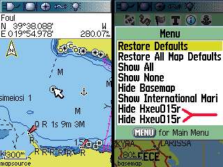
From map screen press Menu->Setup Map->Enter->Menu, and check if it says "Hide" next to it, then it's OK and the map should be visible.
If it says "Show" move down, highlight the map and press Enter to change "Show" to "Hide".


-
15th June 2012, 12:50 AM #8VIP Master


- Join Date
- May 2009
- Location
- Maryland
- Posts
- 233
- Rep Power
- 20
-
15th June 2012, 01:25 AM #9Navigation software expert


- Join Date
- Apr 2009
- Location
- Suomi-Russia
- Age
- 58
- Posts
- 2,149
- Rep Power
- 729

It is discussed more than once. Bluechart G2 have non-transparent (digitized charts) and transparent (synthesized fishing maps) maps. Some device like old handhelder show non-transparent and transparent maps in list separately. There is a logic because in this device there is not switching between chart or fishing maps. The same situation take place with some integrated in mapset the transparent maps of relief.
Garmin, how much is 30 pieces of silver for Judas today? Were they worthy for crucifix of GPSPower?
-
21st August 2012, 10:30 PM #10Junior Member


- Join Date
- Aug 2010
- Location
- Panama
- Posts
- 9
- Rep Power
- 0

Hi X-Trail,
I have the same GPS unit, 60CSx and I did everything you mention in your post but I still unable to see the map on the GPS unit, what can I be doing wrong?
I can see the complete map on the PC without problem.


 Likes:
 Reply With Quote


Bookmarks