Welcome guest, is this your first visit? Click the "Create Account" button now to join.
Results 1 to 1 of 1
-
4th November 2010, 10:50 PM #1
 Garmin VUS024R Wrangell To Dixon Ent Bluechart G2 Vision (9.00)
Garmin VUS024R Wrangell To Dixon Ent Bluechart G2 Vision (9.00)
Garmin VUS024R Wrangell To Dixon Ent Bluechart G2 Vision (9.00)

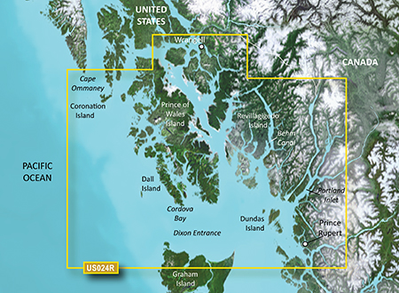
Detailed coverage from Cape Ommaney to Prince Rupert including Prince of Wales Island, Dixon Entrance, Wrangell, AK, Behm Canal, and Observatory Inlet.
Get a fresh perspective when you take to the water with BlueChart® g2 Vision®. With BlueChart g2 Vision data, you’ll get detailed marine cartography that provides convenient viewing of nautical content and other premium features. BlueChart g2 Vision allows you to see your vessel’s precise, on-chart position in relation to navaids, coastal features, anchorages, obstructions, waterways, restricted areas and more. You will also have access to detailed mapping capabilities that include Safety Shading¹, Fishing Charts¹, smooth data transition between zoom levels, harmonious transition across chart borders, and reduction of chart discontinuities. Premium features include 3-D perspective above and below the waterline, Auto Guidance, high-resolution imagery, and “real picture” aerial photos of ports, harbors, marinas, waterways, landmarks and other points of interest
locked map
PID 1, FID 232, region 1,35
download
[Only registered and activated users can see links. ]
thanks to a friend who provided it


You have to navigate to get to the good.
Galaxy S5 Kitkat 4.4.2 / Nuvi1200->1250 / Nuvi3790T->34xx / Nuvi 2200 / Nuvi 66 / Oregon 600


 Likes:


Bookmarks