--------------------------------------------------------------------------------
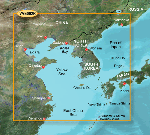
BlueChart G2 Vision - 3D View Yellow Sea VAE002R
[Only registered and activated users can see links. ]
[Only registered and activated users can see links. ]
[Only registered and activated users can see links. ]
[Only registered and activated users can see links. ]
[Only registered and activated users can see links. ]
[Only registered and activated users can see links. ]
[Only registered and activated users can see links. ]
[Only registered and activated users can see links. ]
[Only registered and activated users can see links. ]
mapid: 264
infos
Code:Please Login or Register to see the links
Welcome guest, is this your first visit? Click the "Create Account" button now to join.
Results 1 to 7 of 7
Hybrid View
-
29th September 2008, 10:57 PM #1
 Garmin BlueChart G2 Vision Yellow Sea
Last edited by catymag; 24th February 2012 at 02:32 PM. Reason: replaced links thanks Jamie

You have to navigate to get to the good.
Galaxy S5 Kitkat 4.4.2 / Nuvi1200->1250 / Nuvi3790T->34xx / Nuvi 2200 / Nuvi 66 / Oregon 600
-
17th November 2009, 01:37 PM #2VIP Master


- Join Date
- Nov 2009
- Posts
- 13
- Rep Power
- 0

Hi catymag
It seems the file not on the rapidshare any more.
-
17th November 2009, 03:13 PM #3

Last edited by Midnight Blues; 17th November 2009 at 03:16 PM.
-
17th November 2009, 04:01 PM #4
-
26th January 2011, 03:14 PM #5
-
26th January 2011, 05:13 PM #6Member +


- Join Date
- Dec 2008
- Location
- Canada
- Posts
- 35
- Rep Power
- 98
-
24th February 2012, 04:37 AM #7

[Only registered and activated users can see links. ]
[Only registered and activated users can see links. ]
[Only registered and activated users can see links. ]
[Only registered and activated users can see links. ]
[Only registered and activated users can see links. ]
[Only registered and activated users can see links. ]
[Only registered and activated users can see links. ]
[Only registered and activated users can see links. ]
[Only registered and activated users can see links. ]


 Likes:


Bookmarks