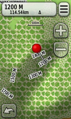
Topodrive Hellas has been created to meet the needs of navigation of on & off-road. This isn't a simple roadmap or a topographic map, it's the map that will lead you to your destination by car and will continue to guide you to hiking, hunting or in the trail with your bike.
Topodrive Hellas includeds all the information of AutoDrive Hellas which is the map for use in car navigation devices.
Topodrive Hellas includes the coverage of AutoDrive Hellas:
412,000 km road network
195,000 points of interest
44,000 toponymies
12,500 towns and villages with full resolution
Entire hydrographic network
Unpaved throughout Greece
Plus the following:
Digital terrain model accuracy 1:5000
Contours every 10 meters
Trail network throughout Greece - National and International
Color display land use, forest, farming land etc.
Upgrades
2011.B (1st) version:
International and National Trails + Peloponnese.
Total 5100 km (3250 km section of road + 1850 km 'clean' paths)
2012.Α version:
Athens + Thessaloniki, Sterea except Evia, Serres
Total 7900 km (4550 km section of road + 3350 km 'clean' paths)
2013.A version:
Anat. Macedonia - Thrace, Central Macedonia, Western. Macedonia, Epirus, Thessaly,
Euboea, Lesbos, Chios, Sifnos
Total 12900 km (7250 km section of road + 5650 km 'clean' paths)
Info (Greek only)
Code:Please Login or Register to see the links
Download Original exe files
TopoDrive Hellas v2013.Α Greek
Source 1
Source 2Code:Please Login or Register to see the links
Code:Please Login or Register to see the links
TopoDrive Hellas v2013.Α Latin
Source 1
Source 2Code:Please Login or Register to see the links
Code:Please Login or Register to see the links
Use [Only registered and activated users can see links. ] to extract all files from exe. Well you should know what to do next ...
Welcome guest, is this your first visit? Click the "Create Account" button now to join.
Results 1 to 10 of 24
Thread: TopoDrive Hellas v2013.Α
Threaded View
-
21st October 2013, 09:01 PM #1
 TopoDrive Hellas v2013.Α


 Likes:


 Reply With Quote

Bookmarks