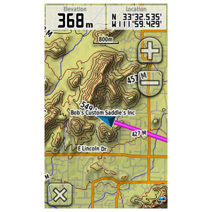
WOW.. this is another interesting map. Very unusual and specific.
Welcome guest, is this your first visit? Click the "Create Account" button now to join.
Results 1 to 8 of 8
Thread: US TrailMaps - Equestrian V 2.00
-
8th May 2013, 06:15 PM #1
 US TrailMaps - Equestrian V 2.00
US TrailMaps - Equestrian V 2.00

Part Number: 010-D0611-00Code:Please Login or Register to see the links
Explore equestrian trails in 16 states throughout the U.S. Conveniently download the maps to your device, and you'll have all the detail you need for your next equestrian outing.
Equestrian trails in 16 states; data provided by US TrailMaps.
more than 20,000 mi (32,000 km) of trails and information.
Includes locations of hitching rails, watering holes, trailer parking areas, horse camping, tack shops, horse training, trailheads, visitor centers, stables, shelters, restrooms and picnic areas.
Includes more than 20,000 mi (32,000 km) of comprehensive equestrian trails and information in Arizona, Arkansas, California, Colorado, Illinois, Indiana, Iowa, Michigan, Minnesota, Missouri, North Carolina, Ohio, Oklahoma, Pennsylvania, Washington and Wisconsin
Certain devices will not display U.S. TrailMaps data at the same time as other map products, such as TOPO 24K or TOPO 100K. In these devices, only 1 map product may be viewed at a time.
locked .img FID 2010
[Only registered and activated users can see links. ]
You have to navigate to get to the good.
Galaxy S5 Kitkat 4.4.2 / Nuvi1200->1250 / Nuvi3790T->34xx / Nuvi 2200 / Nuvi 66 / Oregon 600
-
11th May 2013, 06:04 PM #2VIP Master


- Join Date
- May 2009
- Location
- Maryland
- Posts
- 233
- Rep Power
- 20

-
12th May 2013, 11:44 AM #3

Someone tested this map in Basecamp ? I put the *.img on a virtual drive, Basecamp reads the map but I only see a kind of a Basemap. Cann't find any detail rastermap.
Same with the Whitewater map.
Finding data for this map in Basecamp gives zero results.
Can give anyone coordinates which certainly gives a rastermap.
Or does the map only works on a device ?
-
12th May 2013, 01:05 PM #4
-
12th May 2013, 03:03 PM #5

Last edited by bommelb; 12th May 2013 at 03:09 PM.
-
12th May 2013, 03:29 PM #6
-
12th May 2013, 03:42 PM #7

Yes, that is the solution.
It are only trails and You must combine that trails with an other topomap.
I was to much focused on the rastermap of the Garmin picture, that I don't see the blue trail.
Completely clear now, thank You Catymag.
-
12th May 2013, 04:04 PM #8MapperoniGuest

You can't expect a 4Mb img to contain a US Topo map


 Likes:


 Reply With Quote


Bookmarks