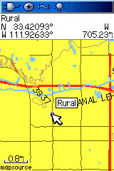
Arizona Topo Map
Introduction
The purpose of this venture is to create a detailed topographic map of the entire state of Arizona at 24k detail. This map is created for Garmin GPS receivers and Mapsource.
Features
■Roads - Interstates, highways, arterial roads, residential roads, limited unpaved roads (2008 Tiger Data)
■Railroads
■High resolution water data - lakes, rivers, streams, and washes
■Federal Land Usage - Wilderness area, national parks, and military bases/ranges, native american reservations
■Borders - County and state boundary lines
■Elevation contours - 40ft intervals (equivalent to 24k)
■GNIS Points of Interest - summits, mines, falls, dams, cemeteries, towers, populated places, etc.
■Trails - trail coverage including: Grand Canyon, Sunrise Ski Park, Granite Mountain Recreation Area trails, National Forests, and a few others
■100k Grid Segments - no segment larger than 6.3mb means most older GPSr's can use this mapset
Coverage
This map covers the entire state of Arizona.
Installation
Two options exist; for windows download and run setup. The map will then appear in Garmin MapSource and can be added to your GPS by selecting it in MapSource and sending it to the GPSr. For Mac download the mac version, extract it and double click the .gmapi file. Map Manager will then install the map for you.
Version 1.25 Released 2 Jan 09
[Only registered and activated users can see links. ] [160MB]
[Only registered and activated users can see links. ] [159MB]
References
Many resources were used to create this map, the main ones are listed here:
■USGS National Elevation Data (NED)
The NED is elevation data provided in raster form by the USGS.Code:Please Login or Register to see the links
■USGS National Hydrography Dataset
The USGS provides hydrographic data in high resolution.Code:Please Login or Register to see the links
■USGS National Geographic Names Information System (GNIS)
The USGS provides locations and names for many features throughout the United States.Code:Please Login or Register to see the links
■Arizona Geographic Information Council
The state of Arizona provides limited detailed information for the state of Arizona.Code:Please Login or Register to see the links
■U.S. National Park Service: GIS Data and Metadata
The National Park Service provides limited data for its parks throughout Arizona.Code:Please Login or Register to see the links
Welcome guest, is this your first visit? Click the "Create Account" button now to join.
 Likes: 0
Results 1 to 5 of 5
Threaded View
-
2nd October 2009, 04:59 PM #1
 Garmin GPSFileDepot Arizona&Idaho&Florida&Hawaii&Mississippi Topo Maps 24k detail
Last edited by catymag; 2nd October 2009 at 05:44 PM.

You have to navigate to get to the good.
Galaxy S5 Kitkat 4.4.2 / Nuvi1200->1250 / Nuvi3790T->34xx / Nuvi 2200 / Nuvi 66 / Oregon 600


 Reply With Quote
Bookmarks