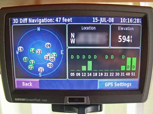
Reading the Nuvis satellites map page

- the green icons are the satellites the nuvi is connected with
- the gray icons are the satellites that the nuvi can see but can't at the moment hooked up
- icons flashing grey/green are ones that the nuvi is attempting to hook up
- the icons are shown in the position in the sky at your present location
- the small round icon with the red centre is the direction your facing/travelling
- the sun icon is the sun position from your present location
- the moon icon is the moon position from your present location
- numbers in the top left is how fast your going (0.0 if your stationary)
- numbers in the top right is your current elevation
- numbers in the bottom left are your current location (Latitude and Longitude)
- bars on the right side are signal strength of the connected satellites

Welcome guest, is this your first visit? Click the "Create Account" button now to join.
Results 1 to 6 of 6
Hybrid View
-
13th June 2010, 01:58 PM #1
 Reading the Nuvis satellites map page
Last edited by catymag; 7th August 2010 at 08:44 PM.

You have to navigate to get to the good.
Galaxy S5 Kitkat 4.4.2 / Nuvi1200->1250 / Nuvi3790T->34xx / Nuvi 2200 / Nuvi 66 / Oregon 600
-
8th July 2010, 02:44 PM #2
 Making sence
Thx
At last I'm seeing the light....
-
19th January 2011, 10:34 PM #3Member +


- Join Date
- Dec 2010
- Location
- usa
- Posts
- 67
- Rep Power
- 17

I think I found more diagnostics features in my 1450. Pressing and holding the top left corner brings up the satellite location page, but inside that page pressing and holding the "Elevation" rectangular box brings up many diagnostic features like memory usage, stacks, fm info, logs etc.
If this is old news then sorry - because i havent seen this posted on here.
-
21st April 2012, 04:33 PM #4Master


- Join Date
- Jun 2006
- Location
- GPS Underground
- Age
- 19
- Posts
- 401
- Rep Power
- 421
 Reading the Garmin Satellite Info Screen
Reading the Garmin Satellite Info Screen
Garmin Nuvi example:

At the top right corner is your location. I�ve removed the coordinates in these examples, but it will show you your current latitude and longitude. Under that is your speed and current elevation, hopefully self explanatory. Under that is where things get interesting. All of the vertical bars correspond to a satellite that the GPS is listening to. The numbers at the bottom refer to a specific satellite number. Here the GPS is listening to 2, 4, 5, 10, 12, 13, 17, 20, 23, and 30. Note that most of the bars are blue. On this GPS that means that the GPS is listening to that satellite and the information being received is good enough to be able to use in the calculation of your current position.
Sometimes you might see a �hollow� bar or a slot for a bar but no bar itself. This is the case with satellite #20. Data from that satellite is not being used to calculate your position. Taller bars indicate better data coming from that satellite. Number 30, 23, and 5 in this case are providing the best reception.
On the left side of the picture is a �map� of the satellites. Think of this as looking down at Earth (the big circle) with North at the top, and your current location centred in the circle. Now thinking of yourself centred in the middle, the outer circle represents the horizon, and the inner circle is looking up at an angle of about 45�.
Satellite #2 is to our West, a little bit North, and fairly high in the sky. (More than 45�.) Similarly, satellite number 4 is to the Northeast and also fairly high in the sky. Number 12 is just about 45� (half way from the horizon to vertical) and is to our Northwest. Number 20, which we are getting little to no reception from, is the furthest away, to the North-east, and is just about on the horizon.
You can also see the current moon position in this view, and the current location of the sun which is about to set to the South-west. There is also a little red dot which indicates our last calculated direction of travel.


-
21st April 2012, 04:48 PM #5

@ Schermann
moved to a previous thread
You have to navigate to get to the good.
Galaxy S5 Kitkat 4.4.2 / Nuvi1200->1250 / Nuvi3790T->34xx / Nuvi 2200 / Nuvi 66 / Oregon 600
-
5th July 2012, 02:25 PM #6

Thanx a lot. An excellent explanation.


 Likes:


 Reply With Quote
Bookmarks