Welcome guest, is this your first visit? Click the "Create Account" button now to join.
 Likes: 0
Results 1 to 1 of 1
-
23rd March 2009, 12:30 PM #1
 Mobile Trail Explorer v1.14 Final -Explore your trails using phone and GPS-*updated* (Java)
Mobile Trail Explorer v1.14 Beta - Explore your trails using the mobile phone and GPS unit (internal/external)

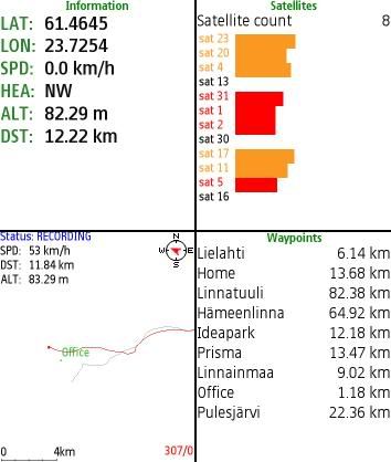
Mobile Trail Explorer is an application where user can view and record tracks using the mobile phone and GPS device (either external or internal). Recorded tracks can be exported in KML or GPX formats so that they can be viewed in Google Earth application. Mobile Trail Explorer is mainly targeted for recording biking, hiking etc. trails.
You can also create trails or placemarks in Google Earth and import those to Mobile Trail Explorer in KML format. You can then display the imported track as “ghost” trail and follow the trail or waypoints.
Mobile Trail Explorer can also post your current location to web in specified URL address. You can send your current location, speed, altitude and heading information in query parameters and do whatever you like with them on your server application.
Mobile Trail Explorer software runs on Java platform (J2ME/Java ME) so it is supported by many mobile phones. It is required that mobile phone supports either Bluetooth connections (JSR 82) or Location API (JSR 179) for GPS and File connection (JSR 75) for exporting trails to kml files.
Platform: Java MIDP-2.0 CLDC-1.1
Version 1.14 :
* New logo and icon
* Improved MapCache initialization time
* Fixed information screen scrolling
* Splash screen hang fix (Issue 106)
* WGS84 coordinates in degrees and minutes (Issue 162, Thanks Marco can Eck)
* Fixed NullPointerException with S40 devices (Issue 145, 164)
* NoSuchFieldError fixed (Issue 166)
* Added decimal check to calculate time form (Issue 167)

hit the +rep to show some appreciation


 Reply With Quote
Bookmarks