Links are dead, can be uploaded again, please?
Thank you!
Welcome guest, is this your first visit? Click the "Create Account" button now to join.
Results 1 to 6 of 6
-
27th September 2009, 02:43 PM #1
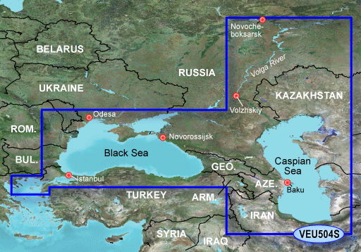
 Garmin bluechart g2 Vision VEU504S-black and caspian sea
Garmin bluechart g2 Vision VEU504S-black and caspian sea
Garmin bluechart g2 Vision VEU504S-black and caspian sea

mapid 234
VEU504S Covers:
Detailed coverage of the entire Black Sea with port plans including Odesa and Trabzon. Coverage also includes the Sea of Azov, Sea of Marmara, and the Bosporus. Detailed coverage of the Caspian Sea in its entirety and the Volga River from Novocheboksarsk to Volzhskiy. Includes Chistopol' and Samara. General coverage of the North Aegean Sea
BlueChart g2 Vision
What is Bluechart® g2 Vision?
Plug an optional BlueChart g2 Vision SD card into your new Garmin chartplotter and tremendously expand its capabilities.
By adding a BlueChart® g2 Vision card to your compatible chartplotter, you'll have access to premium mapping features such as true 3D-view detailed mapping capabilities (both above and below the waterline), plus helpful Auto Guidance, high-resolution imagery, and "real picture" aerial photos of ports, harbors, marinas, waterways, navigation landmarks and other points of interest.
BlueChart g2 Vision Features:
BlueChart g2 Vision SD cards enhance the preloaded maps on your chartplotter and add a whole new dimension of exceptional features such as:
•High resolution satellite imagery, when overlaid on the chart, provides the mariner with unparalleled situational awareness.
•Aerial reference photography provides "real world" photos of ports, harbors, marinas, waterways, navigation landmarks and other points of interest, offering the mariner another powerful tool for navigating unfamiliar waters.
•Mariner's Eye View perspective provides a bird's eye view from behind the boat showing the chart information for a quick, reliable and easy position fix.
•Fish Eye View 3D perspective provides an underwater view that visually represents the sea floor according to the chart's information.
•Auto Guidance technology searches chart data to suggest the best passage to a destination.
•Fishing charts allow the mariner to hide navigation data from the SD card while leaving the bottom contours and depth soundings for their next fishing adventure.
•Includes tides, currents, marine services, coastal roads and points of interest.
•Detailed BlueChart g2 maps are included on the card to supplement the maps on your chartplotter.
BlueChart g2 Vision Compatibility:
•4x0 Series
•400x Series
•420x Series
•5x0 Series
•500x Series
•520x Series
VEU504S ID=234
Download locked IMG-file with VEU504S v9.00 in 1 part RAR-archive (1 665 957 888 bytes when extracted):
This post requires you to click the "LIKE this post" button and hit F5 to read this content.Last edited by catymag; 10th November 2015 at 03:07 PM. Reason: new link added

You have to navigate to get to the good.
Galaxy S5 Kitkat 4.4.2 / Nuvi1200->1250 / Nuvi3790T->34xx / Nuvi 2200 / Nuvi 66 / Oregon 600
-
23rd February 2012, 02:47 PM #2
 dead links...
-
23rd February 2012, 09:09 PM #3BallebarGuest
 New updated links in post #1.
New links in post #1.

-
11th December 2018, 07:11 AM #4Junior Member


- Join Date
- Mar 2017
- Location
- iran
- Posts
- 1
- Rep Power
- 0

Links are dead, can be uploaded again, please?
Thank you!
-
12th February 2019, 06:55 AM #5Junior Member


- Join Date
- Feb 2019
- Location
- romania
- Posts
- 2
- Rep Power
- 0

hello,
Can someone reupload again please ?
thank you in advance !
-
16th February 2019, 01:44 AM #6

Sorry Maps old/post old "Links may have Expired"

NO Request for active Maps/software they will be removed under Rule #9
9- BE RESPECTFUL OF THE LAW . This means no upload of any illegal activities, copyright infringement, or pirated intellectual property.
This applies to Garmin and Tom Tom.
 Can't see a link/attachment? Don't post asking why. Just 'Like' the post & hit F5:
THE LIKE BUTTON IS NOW IN THE BOTTOM LEFT-hand CORNER - If you can't see the like button, then you're an Inactive Member
Posts serving no purpose like thanks or to ask about links go to [Only registered and activated users can see links. ] or are deleted, it's GPS Power policy.


 Likes:


Bookmarks