Welcome guest, is this your first visit? Click the "Create Account" button now to join.
Results 1 to 1 of 1
Thread: img2gps v.2.81
-
2nd December 2009, 01:14 AM #1
 img2gps v.2.81
img2gps v.2.81
img2gps v.2.81
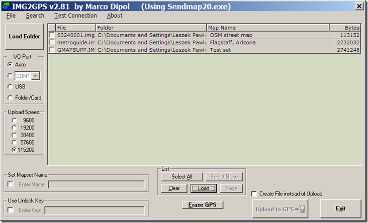
Garmin IMG to GPS Uploader Front-End for SendMap
IMG2GPS is a Windows GUI for the SendMap / Sendmap20 DOS application by gps_mapper.
It will transfer any Map file (.img format) to your Garmin GPS.
It will work for Garmin maps as well as home-made maps.

How to use:
Click the button to 'Load Folder'. Navigate to a folder which contains the .IMG files and click OK (or double-click one of the files in that folder - this will memorize that folder for next time).
A list of all the .img files in that folder will appear.
Select the maps you wish to upload.
Select the port to which your GPS is attached. (Sendmap20 auto-selects the COM/USB port)
Click 'Upload to GPS'.
(Use 'Folder/Card' to copy the maps to a memory card or external drive.)
--------------------------------------------------------------------------------
You can load a text file (with extension .txt or .i2g) or Mapsource file (.gdb) which contains a list of maps. (Click the 'Load' button near the bottom of the screen)
You can also open a map file (.i2g, .txt or .gdb) by right-clicking the file in Windows Explorer and choose 'Open With', then select IMG2GPS to open the file.
If any of the files in this list are invalid or non-existant, they will highlighted with a red X.
You can save the list of selected maps (it will have the .i2g extension). (Click the 'Save' button next to the 'Load' button)
The text file has the following format:
This will set the I/O Port to USB:Code:Please Login or Register to see the links
You can add an unlock code and/or MapSet name:Code:Please Login or Register to see the links
(unlock:1 will tick the box. unlock:0 will untick the box)
This will add the MapSet name of 'test map':Code:Please Login or Register to see the links
(mapset:1 will tick the box. mapset:0 will untick the box)
Code:Please Login or Register to see the links
--------------------------------------------------------------------------------
Possible issues:
Runtime error 53:
You must wait for the Sendmap20 DOS window to finish creating the file before choosing the output folder.
Other reasons may be a problem with the shortcut to IMG2GPS.EXE or your PC is not converting long filenames to short (DOS 8.3) filenames correctly.
Right-click on the Img2gps shortcut (on the desktop and in the 'Programs' list) and choose 'Properties'.
It should show the installed folder in the 'Start In' field.
If the shortcut is ok, try this:
Use 'Debug Mode' (in File menu) to view the DOS command string that is sent to Sendmap20.exe
It should convert the folder/filename to DOS 8.3 format (with no spaces).
E.g. The following long pathname:
E:\UK Garmin Maps\Map Folder\Region A.img
should display as:
E:\UKGARM~1\MAPFOL~1\REGION~1.img
Here is a small program to display Long filenames as Short filenames: [Only registered and activated users can see links. ]
Try it on a file that has spaces in its folder or filename.
If it does not convert the long pathname to a short pathname, then you have a problem with your Windows installation.
You have to navigate to get to the good.
Galaxy S5 Kitkat 4.4.2 / Nuvi1200->1250 / Nuvi3790T->34xx / Nuvi 2200 / Nuvi 66 / Oregon 600


 Likes:


 Reply With Quote
Bookmarks