The link to this application no longer works. It is a generic page and the file cannot be found/downloaded. Do you know anywhere else I can find it??????
Thanx
Welcome guest, is this your first visit? Click the "Create Account" button now to join.
Results 1 to 4 of 4
-
4th May 2009, 02:51 PM #1
 KML To GPX Converter For PC And Mac
KML To GPX Converter For PC And Mac
KML To GPX Converter For PC And Mac

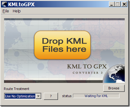
KMLtoGPX 2.0 is a simple program for converting Google Earth KML files to the GPS-compatible GPX format. It’s written in Java, and the website has downloadable version for both PC and Mac. Can’t test the Mac version, but the PC interface is simple:
Drag and drop the KML file onto the button (or use the File => Open command to select a KML file), and a file save dialog will come up asking you where to save the GPX file.Code:Please Login or Register to see the links
It works, but has limitations:
Points and lines only; no polygons
The dropdown at the lower left is supposed to let you choose a simplification mode for lines, where the default of “Use No Optimization” is supposed to use every point in the line. But on this default setting, lines don’t convert properly; only the starting point of the line is converted to GPX format. You have to select one of the other two line options to have the KML path convert correctly to a GPX route: “Use LRO” simplifies the line; “Use End To End” drops all points except the start and end and is only really useful if you just want a straight line.
It modifies the point names, and doesn’t import path names.
If you have a Mac, which has few free options for handling KML to GPX conversions, this might be an acceptable choice. For PCs though, there are better choices, some of which also support polygons:
[Only registered and activated users can see links. ]
[Only registered and activated users can see links. ]
[Only registered and activated users can see links. ]
You have to navigate to get to the good.
Galaxy S5 Kitkat 4.4.2 / Nuvi1200->1250 / Nuvi3790T->34xx / Nuvi 2200 / Nuvi 66 / Oregon 600
-
16th September 2009, 11:58 PM #2fatboy111Guest
 Dead Link
-
19th September 2009, 04:34 PM #3

Last edited by catymag; 19th September 2009 at 04:48 PM.

You have to navigate to get to the good.
Galaxy S5 Kitkat 4.4.2 / Nuvi1200->1250 / Nuvi3790T->34xx / Nuvi 2200 / Nuvi 66 / Oregon 600
-
11th January 2011, 11:53 AM #4ronyxqdGuest

please give me gpstrackmaker pro 4.7 with license or patch or ***** , please give me link download....
thanks.


 Likes:


 Reply With Quote
Bookmarks